 Population2,051 (July 1, 2025 Census estimate)
Open Wheat Country Between Deep River Canyons
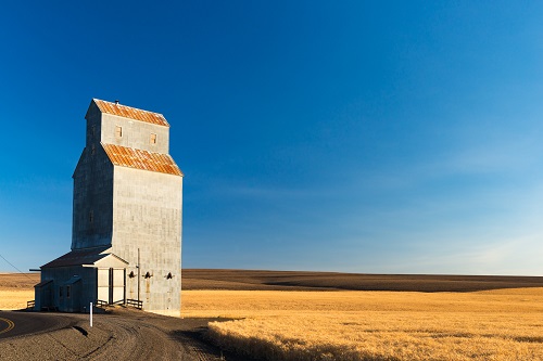
Sherman County, OregonMoro anchors Sherman County, where rolling wheat fields contrast with the canyons of the Columbia, John Day and Deschutes rivers. Grass Valley, Rufus and Wasco add community centers, while the county museum and historic courthouse give the agricultural landscape a civic and historical focus. The U.S. Census Bureau estimated 2,051 residents in Sherman County, Oregon, on July 1, 2025.
Sherman County at a Glance
Population2,051 (July 1, 2025 Census estimate) County SeatMoro
 Largest MunicipalitySee local community resources
 Established1889 (organized; NACo County Explorer)
 ZIP CodesUse USPS ZIP Code Lookup
 Total Area, Including Water831.188 square miles, including water (2020 Census geography)
 Major RoutesCheck TripCheck for routes
 Area CodesCheck the listed local contact
Shop - Dine - Discover

Meet Local Businesses
Support the businesses that help make our communities thrive. From family-owned shops and restaurants to trusted local services, discover businesses worth visiting throughout the county.
Discover Sherman County
Sherman County
Sherman County was created from northeastern Wasco County in 1889 and named for William Tecumseh Sherman. Wind-deposited soils support its wheat-growing landscape, while river canyons define important boundaries. Agriculture, cattle and later wind energy contribute to a working identity that is visible across the open hills around its towns. The town network gives these broad geographic features a human scale. Reading the grain landscape alongside the canyon boundaries helps connect local work with the county's administrative and community history.
Combine Moro's museum or courthouse setting with a carefully selected river destination. The Deschutes, John Day and Columbia offer different access points and activities. The journey between them also reveals the grain-growing landscape that gives the county much of its character. Plan travel time between the plateau and a selected river access point. A museum stop can provide context for the agricultural landscape encountered along the way, instead of merely passing through.
What Shapes Us
Local Character
Moro anchors Sherman County, where rolling wheat fields contrast with the canyons of the Columbia, John Day and Deschutes rivers.
Community History
Sherman County was created from northeastern Wasco County in 1889 and named for William Tecumseh Sherman. Wind-deposited soils support its wheat-growing landscape, while river canyons define important boundaries.
Explore Locally
Combine Moro's museum or courthouse setting with a carefully selected river destination. The Deschutes, John Day and Columbia offer different access points and activities.
Discover open country through its towns and river edges.
A Closer Look
Sherman County
Places and perspectives from Sherman County
OPB — Oregon & Regional News
In the first full day of loss, Bend learns more about Silver Rail shooting, mourns the victims
As Bend residents come together to mourn and ask what comes next, OPB journalists are in Central Oregon.…
Read the Story Oct 17, 2026 • 2 min read
Around Sherman County
Stories from every corner of Sherman County.

In the first full day of loss, Bend learns more about Silver Rail shooting, mourns the victims
As Bend residents come together to mourn and ask what comes next, OPB journalists are in Central Oregon.…
Oct 17, 2026 • 2 min read
OPB’s First Look: New details emerge in Bend school shooting
Multiple people tried to stop the shooter, police said. Here’s your First Look at Saturday’s news.
Oct 17, 2026 • 2 min read
Zelenskyy urges support for new US sanctions on Russia after Trump puts them on hold
Zelenskyy described the move as unfortunate, adding it would encourage Russia to continue its assault. Trump told Congress…
Oct 17, 2026 • 2 min read
Scuffles and fires break out as protesters rally across France, joining students
Demonstrators across France converged with students Saturday to protest rising living costs, as the country's fiscal crisis deepens.
Oct 17, 2026 • 2 min read
Decades after apartheid, South Africans seek justice for crimes of the past
More than three decades after the end of apartheid, families of victims of some of the worst crimes…
Oct 17, 2026 • 2 min read
Shop - Dine - Discover
Meet Local Businesses
Support the businesses that help make our communities thrive. From family-owned shops and restaurants to trusted local services, discover businesses worth visiting throughout the county.
County Resources
Find the Right Local Connection
Start with the organization responsible for the service you need. Follow its official link for current requirements, office locations and availability.
Government
Find official Oregon and county service contacts through Oregon.gov.
Schools
Public school contacts
Selected local schools from the NCES 2024-2025 directory. Contact the school or district to confirm enrollment, attendance boundaries and current services; this is not a complete school list.
Sherman County School – Other; grades KG-12. 65912 High School Lp, Moro, OR 97039. 541-565-3500.
Health resources
Find official Oregon and county service contacts through Oregon.gov.
Public safety
Find official Oregon and county service contacts through Oregon.gov.
Emergency services
Find official Oregon and county service contacts through Oregon.gov.
State parks
Find official Oregon and county service contacts through Oregon.gov.
Trails
Find official Oregon and county service contacts through Oregon.gov.
Utilities
Find official Oregon and county service contacts through Oregon.gov.
Libraries
Local library contacts
Locations and public phone numbers are from the IMLS FY2024 Public Libraries Survey. Call the branch to confirm current hours and services before visiting.
Sherman County Public/School Library – 65912 High School Loop, Moro, OR 97039. 541-565-3279.
Courts
Find official Oregon and county service contacts through Oregon.gov.
DMV
Oregon — Schedule, Cancel or Change an Appointment
Oregon — Driver license applications for adults
Transportation
Find official Oregon and county service contacts through Oregon.gov.
Postal Services
USPS location finder — Search by street address, city or ZIP Code for nearby post offices, collection boxes and available services.
USPS ZIP Code lookup — Find the mailing ZIP Code for a specific street address.
USPS Hold Mail — Arrange a temporary mail hold and review identity-verification requirements.
USPS change of address and forwarding — Review forwarding options and submit an address-change request through USPS.
USPS package pickup — Check pickup availability for your address and schedule eligible shipments.
Veterans
National services available to local residents
VA accredited representatives — Find help with VA claims and benefit applications.
VA health care applications — Review application options and supporting information.
VA disability claims — Find the official steps for submitting a disability claim.
GI Bill and education benefits — Review how to apply for VA education benefits.
Veteran career and employment support — Explore VA employment, training and career assistance.
Employment
National services available to local residents
USAJOBS federal employment — Search federal openings by location and occupation.
Apprenticeship Finder — Search apprenticeship opportunities by location and occupation.
My Next Move career exploration — Explore occupations, industries and career interests.
Government job-training resources — Find routes to state training programs and support for different job seekers.
Unemployment benefit guidance — Find your state program and its application and eligibility information.
Get to Know Sherman County
Useful answers for residents, visitors and anyone planning their next step.
Local Questions
Sherman County Questions, Answered
Explore practical details about the county and the organizations that serve it.
2,051 (July 1, 2025 Census estimate). This is a dated Census Bureau estimate, rather than a live resident count.
831.188 square miles, including water (2020 Census geography). The total combines land and water area.
Start with these official Oregon resources: Schedule, Cancel or Change an Appointment; Driver license applications for adults; Offices. Choose the page for the service you need, then check its office or online instructions before making a trip. These links cover state services; they do not establish that every transaction is available at a county office.
Use USPS ZIP Code Lookup for the mailing ZIP Code of a specific street address. Use the USPS location finder to search for nearby postal facilities and available services. An address lookup is more useful for mailing than assuming the entire county shares one ZIP Code.
The VA explains how to find and appoint an accredited representative for benefit claims. Contact a representative to confirm availability before appointing them. For education benefits, use the GI Bill application guidance. These are national VA services available to eligible local residents, rather than a listing of county offices.
Search USAJOBS for federal positions and the Apprenticeship Finder for apprenticeship opportunities, using location filters to narrow the results. USAGov job-training guidance points to training programs and state resources. Check each listing for current availability, eligibility and application instructions; a search result does not guarantee an opening in the county.
Sherman County was created from northeastern Wasco County in 1889 and named for William Tecumseh Sherman. Wind-deposited soils support its wheat-growing landscape, while river canyons define important boundaries. Agriculture, cattle and later wind energy contribute to a working identity that is visible across the open hills around its towns. The town network gives these broad geographic features a human scale. Reading the grain landscape alongside the canyon boundaries helps connect local work with the county’s administrative and community history.
Combine Moro’s museum or courthouse setting with a carefully selected river destination. The Deschutes, John Day and Columbia offer different access points and activities. The journey between them also reveals the grain-growing landscape that gives the county much of its character. Plan travel time between the plateau and a selected river access point. A museum stop can provide context for the agricultural landscape encountered along the way, instead of merely passing through.
The 2020 Census geography figures record 823.614 square miles of land and 7.574 square miles of water in Sherman County. The county’s total area includes both. These are geographic measurements for that Census vintage, not a measurement of current water levels or public recreation access.
In the Census Bureau’s 2025 estimate series, Sherman County had an estimated 1,880 residents on July 1, 2020, and 2,051 on July 1, 2025. Over that interval, the estimated population increased by 171 residents, or about 9.1%. Both figures come from the same estimate vintage, which revises earlier years for a consistent comparison.
Moro is the county seat listed for Sherman County by the National Association of Counties. For an office visit, confirm the specific department’s address before traveling. NACo county profile.
Shop - Dine - Discover
Meet Local Businesses
Support the businesses that help make our communities thrive. From family-owned shops and restaurants to trusted local services, discover businesses worth visiting throughout the county.
My Local Guide
Explore Sherman County
Places to visitExplore Moro’s history, wheat-country towns and the county’s river canyons.
- Sherman County Historical Museum in Moro
- Historic courthouse in Moro
- Wasco and its wheat-country surroundings
- Columbia River near Rufus
- Deschutes River canyon
- John Day River canyon
Explore the Sherman County profile in the Oregon Blue Book
County photograph: Oregon State Archives, via Oregon Blue Book. County profile and map: Oregon Secretary of State.
Plan your visitCheck current access and hours before heading out.